By: Valrie Grant, Managing Director, GeoTechVision
The application of Geographic Information Systems (GIS) has become all pervasive. It is used in almost everything that we do and everywhere we go. Agricul-ture is no exception. Agriculture Geographic Information System) (AGIS) makes a significant contribution to the creation of safe and efficient farming practices and to increasing yield and is particularly relevant in Guyana, one of the major farming communities in the Caribbean.
Crop cultivation and management
The greatest benefits from GIS are gained in large-scale farming. Small farms can however, use aspects of the technology to great benefit, eg in crop planting (mapping where crops are planted or to be planted) and crop rotation management. One of the most critical aspects of farming is that of managing resources efficiently. To do so, sufficient data must be gathered regarding the extent of resources available and their condition. This applies to plot size, new crop growth, soil type, crop yield, terrain topography, soil moisture content, pest control and fertilizer distribution, among other things. All of these elements have direct relation to the “ground” or location. This is where the role of GIS is realized. The technology has the capacity to provide location intelligence, that is, the ability to derive meaningful insight from geospatial data relationships to address challenges and make decisions.

In the area of crop management, data must be collected either at predefined GPS reference points or at random GPS sample points – depending on the purpose of the required data. The data may relate to the soil or to the crops themselves. Location data (geospatial data) coupled with other scientific or descriptive information about each sample point is then used in analyzing soil and crop characteristics. The output of these analyses provides information and insights that can be used to improve farming efficiencies.
To enable efficient farming and utilization of resources these different sets of data must be collected, referenced to a location, stored, and analyzed to present a clear picture of what is happening on a farm.
Crop optimization
Crop optimization is the practice of accurate measurement of soil type in order to determine the crops best suited to cultivation in that soil. Soil content will change over the lifetime of a crop and keeping soil content within a defined range will assist in ensuring the anticipated crop yield.
Where organic farming is being promoted, the application of more technology has been shown to help reduce the use of chemicals that have long-term negative effects on the environment. AGIS is one such technology.
The use of AGIS along with related technologies can take farmers deep into the realm of precision farming, a circumstance in which farming takes place in a highly controlled and predictable environment. This kind of farming generates large volumes of location-based data, which is what an AGIS system needs to provide the kinds of farming intelligence that drives efficiencies in the agriculture sector.
Crop damage surveillance
In the agricultural sector it is important that farmers are able to anticipate situations in which crop losses are likely to occur due to flooding, drought, wind storms, fire or pest invasion. Utilizing AGIS and drone surveillance techniques it is possible to secure a clear and quick picture of the likely extent of crop damage.
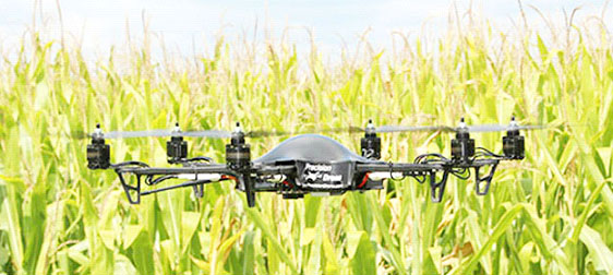
Drone technology pre-programmes a flight path in an Unmanned Aerial Vehicle (UAV). The vehicle is flown over the cultivated area to collect images and relay these directly to a control station or to download the data into a GIS system on the return of the UAV. These images and videos can then be analyzed by a trained farming analyst to secure the needed informa-tion. This method is not only time-saving; it also provides significantly quicker results.
AGIS can be particularly useful to Guyana’s agricultural sector in large-scale cultivation. Sugar and rice are the best examples. Here, the application of GIS and drone technology can greatly improve farming efficiency in a range of areas including monitoring crop growth and maturity, monitoring irrigation systems and water delivery and checking on the state of other critical farming resources/infrastructure including pumps. Drones can be used to help with develop improved planting and crop rotation strategies, and provide better all-around knowledge of how crops are progressing in different parts of a given field. Farmers can utilize this information to determine if they need to change seeds or require more or less fertilizer or different soil nutrients altogether. These technologies can also be used to determine what is needed to increase yield and reduce operating costs, thus enhancing the profitability of farming operations.
Can the small farmers benefit from AGIS technology? While this technology is applied primarily on large farms, smaller farmers may form strategic alliances through cooperatives to enable access to this technology. In those countries where small agricultural endeavours are common, government may also look at including GIS technology as a part of the country’s agricultural Infrastructure.
In some countries, drone technology and GIS is used by government agencies to validate claims for crop losses and/or damages. How would this benefit Guyana? As Guyana looks closer at the introduction of crop insurance, technologies like GIS and drones will assume a higher level of importance. The country’s devastating floods of 2005 serve as a timely reminder that crop damage assessment technology are critical tools in the country’s agricultural sector. It would be a step in the right direction if a farmer can simply stand next to an insurance agent near the rice fields in Berbice or Essequibo and launch a drone which would intelligently survey the area and provide accurate feedback on the extent of crop damage to facilitate the processing of an insurance claim.
A few years ago I undertook a European Union (EU) project in Jamaica following a tropical storm which caused severe damage to banana fields. Field teams used GPS devices to map the extent of the damage and downloaded the data to conduct analyses that allowed for a determination of the extent of damage compensation to which farmers were entitled. GIS technology made this a quicker, more efficient process.
Throughout human history, agricultural planning has been, to a large extent, a matter of guesswork. GIS has removed guesswork by facilitating effective collection of soil data and necessary information.
Droughts, floods, swarms of insects and poor farming techniques have plagued agricultural communities for centuries. GIS has allowed for better ensuring crop safety. Geographic Informa-tion Systems are extremely helpful in being able to map and make projections on current and future fluctuations in precipitation, temperature, crop output, and more. GIS can analyze soil data combined with historical farming practices to determine the best crops to cultivated, where they should be planted, and how to maintain soil nutrition levels.
With GIS, real time control of what is happening in the field has become possible. GIS is helping farmers to increase farm efficiencies and improve economic and environmental conditions in many countries. Here in the Caribbean greater attention is now being paid to these technologies and how they can become part of the national infrastructure for agricultural management. Some governments are mapping the locations of farms and including data like the types of crop grown so that a national production picture can quickly be obtained and production gaps plugged where these exist.
According to FAO Director General José Graziano da Silva, agriculture, particularly family farming, is crucial if the Caribbean is to achieve food security. Accordingly, Guyana and the rest of the region must continue to seek ways of taking farming efficiency to ever higher levels. In this regard there can be no gainsaying the relevance nor the benefits of embracing GIS in the agricultural sector.