Flooding affects Canal No.2
Heavy rain over the past several days has raised the water level in the West Demerara Conservancy resulting in minor overtopping in some low-lying areas but it is “pretty safe at this point in time”, Region Three Chairman Julius Faerber says.

Meantime, with the opening of the kokers, water that had earlier flooded some areas had largely receded though there were some pockets where water remained on the land. But fears were also expressed about the weather and the results of further heavy rainfall and Faerber stated that the situation was being monitored on a 24-hour basis.

In the backlands of the Boersarie conservancy yesterday, rain was falling and this newspaper was informed that the water level in the conservancy had risen about two feet since Tuesday. Faerber told this newspaper that the water level yesterday was at 61.4 GD (Georgetown Datum) and the conservancy has a capacity for 62.5 GD so there was “about a foot to play with”. At one section, however, the water level was almost parallel with the top of the dam.
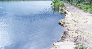
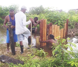
Persons, who live close to the conservancy at Canal Number Two, told Stabroek News yesterday that between Wednesday night and yesterday morning, the water had risen rapidly and at several points it began to flow over the dam. This was at a section at Canal Number Two. Yesterday several sandbags were placed at the vulnerable areas and there was even a tiny makeshift dam but through which water still trickled.
The yards of several homes were flooded, though in most, the water had receded. One resident, who declined to have his name published, said that since Tuesday his yard had flooded and though some water had run off, much still remained. He asserted that a fish farm, further south along the conservancy, was to be blamed for the slow running off of the water.
Aloysious Thom, who farms in the backlands, said that his farm was flooded with two feet of water and he had to move out of his camp. He said this occurred on Tuesday and the water was still high. He said that other farmers were also flooded out. “It look like we got to move out of there”, he stated adding that every time, the rain falls, the place floods.
Faerber said that the water in several areas that were flooded is receding and water was being released at three sluices including the Naamryck and Five Door sluices. He said that the section where the overtopping had occurred was where farmers formerly transported logs across the dam and it was low-lying. He said that the Guyana Sugar Corporation, which has responsibility for the dam, was asked to place some sandbags there and had done so. He noted that the section was also low due to erosion and declared that the Conservancy was being monitored on a 24-hour basis.
In a few other areas, that this newspaper visited, some residents were making preparations for more rain and activities included the clearing of drains. Stabroek News was reliably informed too that water had also overtopped the dam at a point, further south along the conservancy but this situation has since been rectified. The Hydrometeorological Division of the Ministry of Agriculture has forecast more rain in the coming days.


