Exceptionally high tides, waves and winds are predicted from this period until Friday and the Maritime Administration Department (MARAD) is warning all vessels navigating in Guyana’s waters to navigate with extreme caution.
Similar conditions are expected to occur from March 23-31, MARAD has also warned. In a notice in yesterday’s Stabroek News, the agency reminded all operators, passengers and fishermen on vessels operating offshore to wear life-jackets and have all other life-saving equipment secured on board. The notice comes as the south and eastern Caribbean braces for a frontal system this weekend.
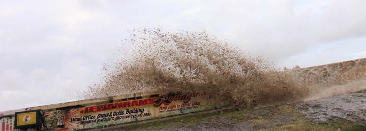
Similar conditions in the middle of January led to waves crashing over the seawall along the East Coast highway and crippling traffic along the thoroughfare. Residents there had said they had seen nothing like it before.
The local meteorological office in a statement issued then had said: “The Coastal Guyana has been under threat by spring tides since Tuesday 8th Jan 2013. Unfortunately, on Monday 14th Jan 2013 a frontal system passed through the Atlantic, just north east of the Lesser Antilles. This supported increase in wind flow/speeds resulting from this weather system coupled with the spring tides would have created the type of storm surges experience yesterday afternoon along Guyana’s coast.”
Meantime, in Trinidad, sea bathers, small craft operators and persons involved in any other sea-related activities this weekend are being asked to exercise extreme caution as there is expected to be “large battering waves” along exposed coastlines. Also, those residing along coastal areas are warned to be on the alert for above normal sea conditions.
The warnings were issued yesterday by the Trinidad and Tobago Meteorological Services, according to the Trinidad Express.
It stated that Numerical Weather Prediction (NWP) models forecast wave heights and swells to be in excess of 2.5 metres, with long periods between wave crests by last evening.
This would result in seas being rendered hazardous, particularly along exposed coasts of Trinidad and Tobago. Tobago was expected to experience the effects earlier than Trinidad, according to the Express
“This is generated by swells generated by the passage of a frontal system associated with Low Pressure System presently in the Western Atlantic. These swells are forecast to propagate to the Eastern Caribbean by Saturday March 9… All necessary measures must be taken to preserve life and property,” the release stated.