(Barbados Nation):‘Beryl’ has been downgraded to a Tropical Storm and is expected to weaken further in the next 48 however. However, according to the latest update from the Barbados Meteorological Office Barbados continues to be under storm watch.
On its present track, the centre of Tropical Storm Beryl is estimated to pass between 100 and 115 miles (160 to 185 km) north of Barbados late tomorrow/ early Monday before moving over the northern Lesser Antilles.
Storm conditions with wind-speeds between 39 mph and 73 mph (63 to 117 km/h) are possible within the watch area in this case within 12 to 24 hours.
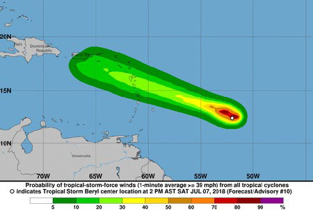
At 5 p.m. Tropical Storm ‘Beryl’ was located near12.7N 52.7W, about 450 miles (725 km) east of Barbados.
Present movement is towards the west-northwest at 17 mph (28 km/h). Estimated minimum central pressure is 1003 MB (29.62 inches).
Maximum sustained winds have decreased to near 50 mph (85 km/h) and additional weakening is forecast. Storm force winds extend up to 45 miles (75km) from the centre of Beryl.
Pockets of moderate to heavy showers and occasional gusty winds are forecast over Barbados Sunday afternoon into Monday and rainfall accumulations of 25 – 50mm (1 to 2inches) with isolated higher amounts are possible over some sections of Barbados.
Due to the continued weakening of Beryl throughout the course of the day, swells are now only expected to reach between 2.5 to 3.0m (8 to 10ft). Thus, a Small-craft Warning will be in effect for Barbados from 6 a.m. Sunday, July 8, 2018. A Small-Craft Warning means in this case that seas equal to or greater than 3m (10ft) will be affecting the marine area.