(TRINIDAD GUARDIAN) Prepare—and pray.
That’s the word from Local Government Minister Kazim Hosein and muncipal authorities yesterday as Tropical Storm Kirk swept across the Atlantic, with T&T and neighbouring Windward islands within the path of its extended cone—so far.
The US National Hurricane Centre (NHC) dubbed the storm Kirk after it developed last Saturday at the recent peak of the 2018 hurricane season.

Kirk, which developed at a very southerly latitude, was moving west of Cabo Verde island packing winds of 40 miles (65 km) per hour.
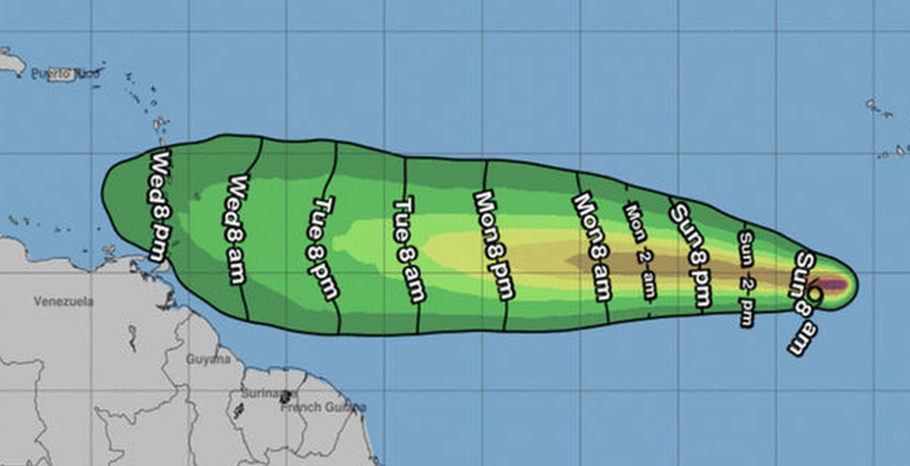
NHC charts most of yesterday showed Kirk’s early formation in latitude line with T&T. Its projected route showed it continuing with a small shift northward as it nears T&T – but with T&T and the most southerly Caribbean islands still in the path of its extended cone.
NHC’s 5 pm bulletin yesterday estimated T&T and the Windwards may get winds by Thursday morning. Other forcasters hope it will run into wind shear and disintegrate.
Yesterday, T&T Meterological Services’ senior duty officer said the department had been getting calls all day from worried people. He noted the storm had formed at a very low southerly latitude like Brett (2017) and Isidore (1990)
“When it forms so far south we do have to be watchful. Brett formed at a lower south level than Kirk and that passed south of T&T. Isidore lost steam in the Atlantic,” the duty officer said.
He said Kirk, up to 6 pm yesterday, was a “minimal” storm.
“We expect it’ll intensify over the next two days but weaken as it approaches the Windward chain. When it reaches about 1200-1500 km east of T&T it may take a more westnorth westerly track to the northern Windwards; probably around Tuesday or Wednesday.”
He said T&T wasn’t under a tropical storm watch/warning, “but we’re monitoring the situation.”
The Windwards comprise Dominica, Martinique, St Lucia, St Vincent and the grenadines, Grenada and T& .
Other islands are also monitoring the storm closely.
AccuWeather expert senior meteorologist Dan Kottlowski, in St Lucia media, said Kirk could threaten parts of the Windwards by Thursday or Friday “with strong perhaps damaging winds and heavy rainfall.”
Action plan 100 hours before storm
Local Government Minister Kazim Hosein said he was informed of Tropical Storm Kirk’s development by 9 pm on Saturday.
He said the Ministry and 14 municipal corporations are closely monitoring Kirk’s path, since T&T currently falls within the storm’s forecasted cone. Hosein said the situation prompted corporations’ Disaster Management Units (DMUs) to begin preparations in the event Kirk reaches local shores later this week.
“I saw pictures of the storm’s path. You can’t take anything lightly. We’re monitoring it but people should take all necessary precaution,” Hosein said.
“You can’t just say ‘God is Trini’ and sit back. It’s all about being prepared. We may not be affected by this storm but we must do what we can to safeguard loved ones and homes. You know I believe in prayer, so whatever religion, seeking God’s help to avert any disaster is also good.”
He added: “I pray it loses steam or veers away from the island chain and we’re not affected. But the DMU’s and ministry are getting organised just in case.”
Hosein’s ministry yesterday issued corporations with a Time Phase Plan detailing steps to be taken from 100 hours prior to the time a storm or hurricane makes landfall. It covers action, including emergency shelter assistance and other relief to the post-storm period.
The ministry encouraged the public to take note of Disaster Management Hotlines for emergency use, to keep monitoring the news to be informed of further developments and to put together emergency kits with reserves of water and other necessities in case they’re needed. The ministry also stressed the public should monitor official weather reports in coming days.
REGIONAL CORPORATION HOTLINES
Diego Martin Regional Corporatio – 800-DMRC (3672)
San Juan/Laventille Regional Corporation – 800-SLRC (7572)
Arima Borough Corporation – 800-2ABC (2222)
Tunapuna/Piarco Regional Corporation – 800-TPRC (8272)
Port-of-Spain City Corporation – 800-PSCC (7722)
Sangre Grande Regional Corporation – 800-SGRC (7472)
Chaguanas Borough Corporation – 800-DCBC (3222)
Couva/Tabaquite/Talparo Regional Corporation – 800-CTTC (2882)
Mayaro/Rio Claro Regional Corporation – 800-4MRC (4672)
Princes Town Regional Corporation – 800-PTRC (7872)
Point Fortin Borough Corporation – 800-PFBC (7322)
San Fernando City Corporation – 800-SCDU (7238)
Penal/Debe Regional Corporation – 800-PDRC (7372)
Siparia Regional Corporation – 800-4SRC (4772)