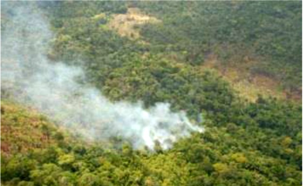
With reports of forest fires in the foothills of the Kanuku Mountains in drought-hit Region 9, the Ministry of Natural Resources and the Environment today said that it recently facilitated an aerial assessment of the area.
Working with its Region 9 partners, including affected communities and Conservation International, the Ministry said in a press release today that it has started monitoring the size, location, direction of movement and speed of the fires.
The first helicopter overflight was done on April 9, 2015 and surveyed the forests, savannahs and mountains around Lethem, Moco Moco, St. Ignatius, Shulinab and Sand Creek villages, the ministry said.
It added that slow moving fires were seen in a number of areas surveyed, with the vast majority moving away from settlements and up the sides of the mountains. It said that much of these fires appear to be burning leaf litter and dry vegetation, and producing significant amounts of smoke that are affecting some areas. However, the fires have not yet been observed consuming mature trees or destroying large areas of forest, the release added.
“As these fires are known to be unpredictable, and with their proliferation being compounded by the extended dry conditions in Region 9, the Ministry will continue to monitoring their movement. The data collected, including any relevant satellite imagery, will be used to strengthen the assessments and mitigation efforts currently being undertaken in the area by the Government. The Ministry calls on all stakeholders to use caution during this period, particularly as communities begin clearing farmlands, and to work together to address the challenges being faced by these affected Regions”, the release said.