
With the Environmental Protection Agency (EPA) yet to build capacity to independently monitor oil extraction activities offshore Guyana, the agency yesterday introduced its real-time monitoring platform to track operations onboard the Liza Destiny FPSO.
The platform along with monitoring information is being provided by ExxonMobil, which is operating Liza Destiny and is being accessed by a slew of government agencies.
Head of the EPA’s Oil and Gas Department Joel Gravesande said that while the platform is still in its testing phase, the agency began real-time monitoring earlier this month. Explaining how the platform functions, he said that it provides real-time data on every aspect of operation on the Floating, Production, Storage and Offloading (FPSO) platform and that includes production, gas, seawater, power generation, SHE (Safety, Health and Environment) and flare management.
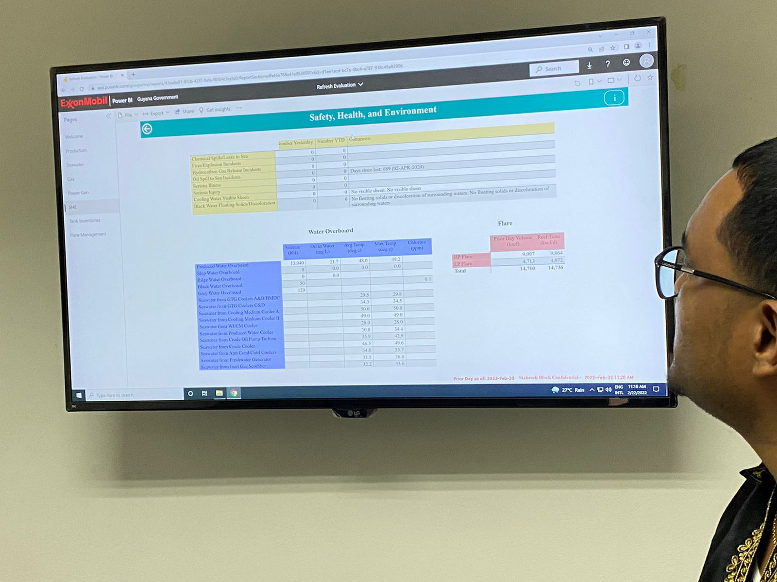
“So some of the aspects that we monitor are chemical spills if there are any chemical spills, fires, hydrocarbon gas releases or flaring, illnesses, injuries, cooling water – if there’s any visible sheen when the cooling water is discharged and of course, black water (if there) is any solid or discolouration,” he added.
Gravesande told members of the media that they have not detected any anomalies since monitoring began.
One of the major concerns for many environmentalists is Exxon’s flaring of natural gas offshore Guyana and the EPA’s inability to monitor to ensure compliance with the relevant permits. Three women, in January of this year, filed a case against the EPA to get it to stop ExxonMobil from flaring natural gas offshore.
ExxonMobil has blamed compressor issues on its ability to minimize flaring. According to reports, the oil giant has paid approximately $930 million for its flaring activities here.
With the new monitoring platform, the EPA is now in a position to more accurately monitor flaring activities since it provides an indication of which valve onboard the FPSO is open and what is being emitted. The active valves are indicated by the colour changing to green on the platform while inactive ones are recorded in red.
Gravesande said that the EPA can see almost immediately when the valve becomes active. He said that the system allows the agency to pinpoint exactly how the gas is being utilized and how much of it is flared as well.
“Added to that, there’s also a gas management system. Of course, you know the gas is brought up from the reservoir and some of it is flared due to the current situation offshore or is used as power generation but the majority of it is re-injected back into the reservoir. So here we have a more holistic view of what happens to that gas as it comes up,” he explained.
The chemical engineer said that the EPA, though the platform, has tremendously improved its monitoring capabilities since it is now able to have an integrated system. Before the implementation of the system, the EPA relied on offshore developers for information and had limited verification capabilities.
Since Guyana began producing oil in 2019, the agency has only conducted a handful of offshore verification activities.
“The agency gets daily reports from the operators with these parameters and of course, the reports are a lot more detailed. So we would get the daily report and now added to this we also get monthly reports. So there are a lot of phases to reporting and of course, we would do our spot checks whenever we can.
“Of course, Guyana started oil production in 2019 and that is when we had the COVID pandemic…EPA did not get the opportunity to go offshore as much as it liked because, of course, safety protocols and the sort of stuff. However, since then we have been going more frequent. We were out there December last to conduct a spot check,” Gravesande, said while explaining that since 2019, the agency only visited the Liza Destiny FPSO five times for “spot checks”.
When questioned about the accuracy of the information being fed into the system, since it was created by the operator of the Liza Destiny FPSO – ExxonMobil, Gravesande said that while he cannot vouch for the data, there are plans to have independent verification as often as possible. He assured that based on the Environmental Protection Act and the various permits issued by the agency, the EPA has unrestricted access to the FPSO and its operation to ensure compliance.
Independent data
Meanwhile, EPA’s GIS specialist Reshana Thomas said that the agency is capable of monitoring Guyana’s 200-mile Exclusive Economic Zone (EEZ) through a number of means independent of Exxon’s platform. She said that the agency has employed the services of SkyTruth which allows tracking of human activities from space.
The EPA is using the cerulean algorithm that automates the processing of sentinel-1 imagery, offshore Guyana.
“Sentinel one imagery is a synthetic aperture radar product. That means that it is able to produce its own energy that’s satellite and it penetrates clouds, which is one of the issues we generally have with satellite imagery here.
“What this cerulean does, it automates the processing of that imagery for an area that we have set up to ask for alerts. So this area that we have set up is the area that’s equivalent to our exclusive economic zone. So after we have asked this algorithm to tell us, if within our exclusive economic zone, any detection for oil spill or slick has been detected (and) if there is an oil spill or a slick detected within this area that we have set up…we will get an email alert,” she explained.
Thomas added that after the email alert is received and it shows either a slick or oil spill then the imagery would show directly where the activity occurred. However, since it is a synthetic aperture radar product it will not transmit any visual imagery of the accident site nor which vessel or operator defaulted.
That is where the agency’s marine tracking subscription comes in. Thomas explained that the marine tracking tool allows the EPA to track every vessel in the EEZ so, in the event of an incident, they could pinpoint the defaulter and take action while setting plans in motion.
“Marine tracking allows us to backdate where our vessel was at a particular date and time and so that would help us to figure out who that defaulter is if it did not indeed come from a developer onshore. So combining these two services is one of the ways we’re able to monitor if unfortunately, there is to be an oil spill or slick event offshore and we would be able to pin that crime to the defaulter,” she explained.
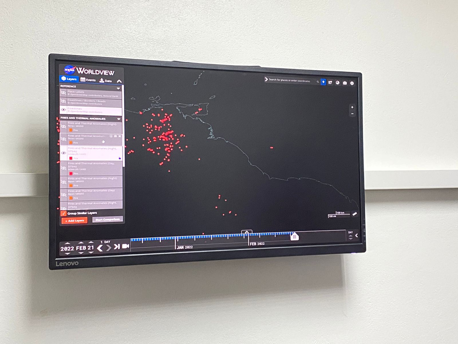
The EPA has also tapped into the National Oceanic and Atmospheric Administration’s bier satellite to access thermal and fire reading offshore Guyana. That way they are also able to monitor flaring. Thomas explained that every thermal anomaly detected offshore Guyana would not amount to flaring but it is the metadata that tells the agency whether it is a flaring activity or not.
“So we’re able to click on any one of these events and this gives us within three hours of an event we’re able to get the alert. This tells us where it has happened, the brightness temperature of the channel and the radiative power based on the radiative powers…if it’s above a certain number that the Oil and Gas Department determined that it is categorized as a flaring activity. Then we take this data and internally do our calculations to determine what the emissions are. This again is compared against what is submitted by the developer so we’re able to say what decisions have to be made or what’s the way forward. So this is just one of the ways that the EPA is able to say independent of the data submitted by the developers to monitor thermal anomalies and signatures offshore,” the GIS specialist related.
Additionally, the EPA has employed the use of the IQAir Clean Air Facility programme to monitor the air quality across Guyana as well as offshore. They have set up sensors in Georgetown, Linden and Berbice with plans to install one in Essequibo and another along the East Coast of Demerara.
“So what IQAir does is it takes the measurements from the equipment that we have set up and models what it thinks the air quality is generally. So all of these other points you’re seeing here are not necessarily sensors, they are modelled air quality based on what is observed from the sensors that we have. It’s also important to note that the sensors capture the air quality for a 20-mile radius,” she explained.
Thus far, Guyana is ranked low when it comes to air pollution.
Improving consistently
Meanwhile, EPA’s Executive Director Kemraj Parsram said that the agency is consistently updating its systems to meet the demand of not just the oil and gas sector but also the other areas.
“Recognizing that that is offshore and with the increasing technology and accessibility technology, we thought it the best that we need to bring in this remote monitoring capability. So on a real-time basis, every single day, every minute, every hour we can keep track of what’s happening in our coastal waters offshore and even on land with our mining and forestry sector and other industries,” he said.
Parsram said that the agency’s $100 million capital budget would go towards more remote monitoring programmes to enhance the agency’s capabilities.