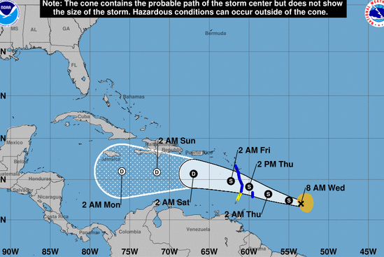
(BARBADOS NATION) At 11 a.m. Tropical Storm Kirk was centred near 12.1N 54.3W or about 360 miles (575 km) east of Barbados.
An Air Force Reserve reconnaissance aircraft investigating Kirk this morning has found the system to be a little stronger.
Maximum sustained winds have increased to near 50 mph (85km/h), with tropical storm force winds extending outward up to 115 miles (185 km) from the centre.
The minimum central pressure was down to 1002mb (29.55 inches).
The system continues to move towards the west at near 18 mph (30 km/h), and on this track, the centre of Kirk is expected to pass about 50 miles to the north of Barbados between Thursday morning and Thursday afternoon.
Sustained surface winds of between 25 to 35 mph (40 to 55 km/h) with gusts to storm force are expected to spread across Barbados starting later tonight and persisting into tomorrow.
In addition, pockets of moderate to heavy showers, periods of rain and scattered thunderstorms are expected. Rainfall accumulations of at least two to four inches (50 to 100 millimetres) are possible between tonight and Friday morning. Some flash-flooding is likely in low-lying areas. Thus, residents are urged to be on the alert and take all necessary precautions.
Large easterly to south-easterly swells of 3.5 to 4.5 (11 to 15ft) are also forecast to accompany the system. These adverse sea-conditions are expected to persist into the week-end when northerly swells being generated by the remnants of Post-Tropical cyclone Leslie in the north-central Atlantic, propagate southwards across the Lesser Antilles.
Low-lying coastlines around the island will be particularly vulnerable at times of high tide.
Large waves and dangerous rip-tides can be expected. These will create unsafe conditions for small-craft operators and fishermen. Sea-bathers and other users of the sea are also advised to stay out of the water. (PR)