The Guyana Lands and Surveys Commission (GLSC) is about to embark on a national remapping exercise after more than half a century but the scheduled start was delayed after a laptop was allegedly stolen from the Canadian company contracted to execute the project.
The laptop has since been replaced and the project is expected to commence soon in regions One and Four. The mapping exercise is part of a US$18 million project that will aid the commission in determining how much land is available and consequently guide decision-making when considering development projects.
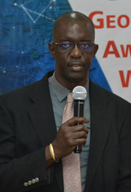
At the commission’s end-of-year press conference yesterday, GLSC Commissioner Trevor Benn said that the laptop, which belongs to North West Geomatics Ltd, a Canadian company, was “illegally removed” from one of the company’s planes. He said that the contractors arrived in Guyana three weeks ago with the intention of starting the mapping exercise but were unable to do so after the alleged theft.
“Unfortunately, when they arrived here three Fridays ago, we had a very ugly incident. A laptop was removed from the airplane without their consent at one of our airports and that delayed our works,” the GLSC head recounted. The laptop has since been replaced.
However, Benn noted that works have been further delayed due to the rainy season. Nonetheless, it was indicated that the exercise would start soon.
Meanwhile, Benn revealed that the project, which was initially estimated to cost US$75 million, is now being done at a cost of US$18 million. It was pointed out that an exercise of this nature was not done in over five decades and it is long overdue in the eyes of the commission.
North West Geomatics’ services were engaged following a procurement process under the guidance of the National Procurement and Tender Administration Board.
“…We are doing it in phases. We cannot take it on as a whole given the cost of it. For this particular supplier, the cost is $18 million US for the entire country. The first time I reported this matter, it was estimated [to be] $75 million US. We shopped around and we want to be able to spend our hard earned money properly so we were able to find someone who would do it for $18 Million [US], the cheapest so far,” Benn explained.
The project is expected to commence in Barima-Waini (Region 1) and parts of Demerara-Mahaica (Region 4) shortly as the company’s team and aircraft are already on the ground. The first phase of the project is estimated to cost US$1.1 million.
“This remapping exercise will provide the platform for updating our national topographic dataset and will support a host of critical government and private sector needs,” Benn pointed out.
Meanwhile, head of the GLSC’s Land Information and Mapping Division, Naseem Nasir, highlighted that mapping is regarded as the basic management of “our resources in terms of managing the land. There is [no way you can] sit in an office and think you can manage a piece of land that you have never seen before.”
Nasir observed that mapping has been recognised by the United Nations as critical to providing fundamental data needed for the development of a country. “One of the things you need to know is what is on the ground now, not what 50 years ago was there. You need to be able to know how much lands is available…to make accurate decisions for development,” he added.
Benn, meanwhile, revealed that the GLSC does not have anyone to analyse the data that will be collected from the mapping exercise but said that they are putting systems in place to address the issue. In January, he said, eight members of staff will undergo training in Canada to develop their skills in analysing the data that will be collected. Some aspects of the training will also be conducted locally. The GLSC commissioner noted that the services of an independent consultant, who is a retired geospatial engineer, will also be used to analyse the data collected.
He disclosed too that they are in the process of procuring several drones which would assist the GLSC to carry out other types of mapping. The drones are being procured through the Sustainable Land Development and Management project, which is funded by the UN Food and Agriculture Organisation.