American deep-sea scientist, Dr Erik Cordes, has informed the Environmental Assessment Board (EAB) that the Environmental Impact Assessment (EIA) for ExxonMobil’s Yellowtail project is seriously deficient and does not paint the correct picture of the impact of its offshore activities.
The opinion was solicited by international lawyer Melinda Janki and the Environmental Law Alliance Worldwide (ELAW). It was submitted to the EAB as part of the public feedback period for the Yellowtail EIA. That period concluded on Wednesday.
Dr Cordes is an Associate Professor and Vice Chair of Biology at Temple University in Philadelphia with over 20 years’ experience in deep sea ecology hydrocarbon seeps and is recognised by his peers as an expert. He has been chief scientist on 10 research cruises. The research in his lab is focused on understanding the areas of the deep sea that support the highest biomass communities: deep-water coral reefs, natural hydrocarbon seeps, and hydrothermal vents. He studies these ecosystems at all levels of organisation – from energy flow in ecosystems and patterns of community assembly, down to gene expression and microbial processes.
The expert reviewed several sections of the EIA that dealt with his area of expertise and produced his findings. He noted that with most offshore projects, like Exxon’s, at the depth of more than 1,000 metres the EIA is missing critical pieces of information that are required to make informed decisions relating to the potential impacts of the Yellowtail project.
With the seeming rush to have the project approved, Dr Cordes highlighted that Environmental Management Resources (ERM) – the consultant selected by ExxonMobil to conduct the EIA – failed to provide substantial data about the distribution of potentially sensitive species for particularly benthic organisms in the area. Benthic organisms refer to organisms living on or near the sea bed.
“I found large parts of the EIA difficult to assess because of the poor quality of the maps provided. There was no position information (latitude and longitude) provided… and the bathymetric data were extremely low resolution, which resulted in very wide-spaced depth contours in the images. Certainly, EEPGL and its partners have higher-resolution multibeam echosounder (MBES) data in the project area, as well as high-resolution seismic reflectivity data that could reveal the presence of hard substrate in the vicinity of the proposed site,” Dr Cordes said in his findings.
Zeroing on the particular sections he looked at, Dr Cordes highlighted that under the heading ‘Marine Geology/Sediments and Marine Benthos’ in the EIA, he found that the overall conclusion of a negligible impact on marine sediments to be particularly questionable.
Pointing to a section of the EIA which states “While the mortality rate of immobile taxa individuals from physical disturbance resulting from installation of the subsea infrastructure will be high, the population is not anticipated to be sensitive to the reduction in individuals within the limited area affected,” Dr Cordes said he is baffled as to how the conclusion was arrived at since there is the glaring absence of data on the population size of potentially sensitive species inside the area of impact and in the region.
He questioned the absence of that data by highlighting ERM’s effort to explain the marine stratigraphy (rock layers) with the provision of high resolution maps measuring the depth ocean. He concluded that those maps indicate that Exxon has access to the data.
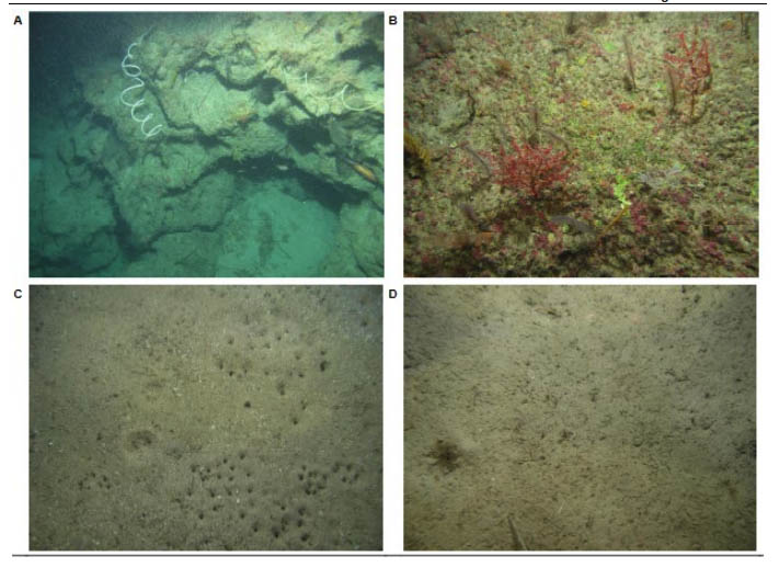
“From this low resolution version of the image, it is still apparent that there are submarine canyons in the area and possibly some hard-substrate areas near the project location. There is also one small area covered by side-scan sonar outside of the proposed project site. Were there no autonomous underwater vehicle (AUV) side-scan data acquired within the project area? These data would reveal areas of high relief that likely represent hard substrate habitats in the vicinity.
“There are also some areas delineated in purple on the map. I suspect that they represent areas of high surface acoustic reflectivity interpreted from the back-scatter of MBES data or from the 3D seismic data that surely exist for this project. These kinds of signals almost invariably indicate the presence of hard-substrate areas. If that is what they are, they are very close to the proposed site, possibly within 2 km, if I am interpreting the grid on the map correctly,” the expert opined.
He also pointed out the scarceness of the data relating to fish. This comes at a time when fishermen have been experiencing low catches and serious questions have been raised about the impact of Exxon’s activities on marine life. Additionally, environmentalists have been continually calling out Exxon for the scant regard it has given to a baseline study for fishes.
ERM in the EIA said that “no fish were captured deeper than 1,000 meters” but Dr Cordes said with the clear absence of studies on the deep-sea fauna of Guyana, there is the possibility of that claim being false. He cemented his opinion in the fact that a recent study of the deep-sea fishes off of the northern coast of Brazil listed 30 fish species with a bathymetric distribution that exceeds 1,000 metres depth.
“…and it is highly likely that the majority of these also occur off of Guyana, as deep-sea fishes, in general, have a very wide distribution. This demonstrates that their sampling of this community was obviously incomplete,” he said.
Sensitive species
He added that ERM’s statements relating to the finds of coral fragments confirm his suspicions of sensitive species in the project area. He said that in numerous places in the EIA, the presence of deep-sea coral species is mentioned, including the reef-forming species Madrepora oculata and Solenosmilia variabilis, as well as long-lived black corals. He also questioned ERM’s assertions that the presence of these species are just “remnant” populations or indications of “nascent recovery” of a past population.
“Based on my 10+ years of experience with photographic surveys from AUVs, this certainly indicates that there are more deep-sea coral populations that remain to be discovered. Interestingly, the corals in Fig. 7. 9-10 do NOT look like black corals, but rather gorgonian octocorals. These samples, and likely many more obtained during the impact assessment surveys, should be examined by a true expert,” he opined.
In conclusion, he stated, “The EIA is deficient and the EPA does not have the scientific and technical information required to make an informed decision about the potential impacts of the proposed project in the Stabroek block. The distribution and abundance of hard substrata, and a complete assessment of the distribution and abundance of hard substrate fauna, including deep-sea corals and cold-seep endemic fauna (chemosynthetic tubeworms and mussels), are required before any conclusions about the impacts on regional populations of sensitive benthic species can be reached. Without this information, this project is highly likely to have greater impacts than those indicated here.”
The Yellowtail project is ExxonMobil and partners’ fourth development in the Stabroek Block and is considered the largest undertaking since Guyana became an oil-producing nation. As part of the Yellowtail Project, ExxonMobil plans to drill between 40 and 67 wells for the 20-year duration of the investment. It is intended to be the largest of the four developments with over 250,000 barrels of oil per day targeted once production commences. Based on the schedule, once approval is granted, engineering commences in 2022 and production in the latter part of 2025.