(Trinidad Guardian) Sweltering heat across parts of Trinidad yesterday ended abruptly, as roaring thunder, strong winds and torrential rain left several without roofs and electricity. Among the many places affected was the Caribbean Airlines hangar at Piarco.
Shortly after midday, according to satellite lightning data, a single isolated thunderstorm developed across south-central Trinidad and rapidly strengthened, producing over 100 lightning strikes per five-minute intervals. Frequent lighting of this magnitude is a hallmark of severe thunderstorm activity. Within 30 minutes, damaging gusty winds began to sweep across parts of Gasparillo, including Bonne Aventure.
A narrow area of heavy to violent rainfall and strong winds moved from Bonne Aventure to Tortuga, Preysal, Chickland, Cunupia and Piarco before the thunderstorm dissipated.
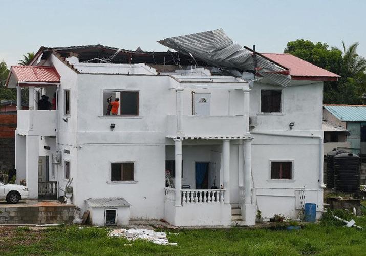
Based on incident reports from the Office of Disaster Preparedness and Management (ODPM) and the Couva/Tabaquite/Talparo Regional Corporation (CTTRC), there were over 11 reports of blown-off roofs, with the majority occurring in Bonne Aventure, Gasparillo, including Surprise Avenue, Bonne Aventure Road, Phekoo Trace, and near the Gasparillo Secondary School.
At the secondary school, a tree and multiple branches fell onto a teacher’s vehicle, while galvanised sheets were blown onto a car at Bonne Aventure Trace.
As the thunderstorm took an atypical path, moving northward across the western half of Trinidad, so did the trail of destruction.
Wind gusts up to 50 kilometres per hour blew off roofs in Couva at Indian Trail Village, Cunupia at Wall Street, Madras Road, and downed trees at Presyal at Boodram Lane. A sign also fell on a vehicle at the corner of the Southern Main Road and Chin Chin Road, Cunupia. Within the Tunapuna/Piarco Regional Corporation, a roof was partially blown off onto electricity lines in Piarco at Golden Grove Road and Arouca at Farm Road.
Meanwhile, gusty winds also caused damage within the Piarco International Airport. Caribbean Airlines Limited (CAL), in a media release, confirmed high winds associated with the early afternoon thunderstorms displaced “several galvanised sheets on a section of Hangars 9 and 10 at its Piarco base”.
CAL added that there “were no injuries, all personnel were safe, and contractors conducted an on-site assessment and secured the loose sheets.”
What caused the severe thunderstorm?
Several features came together yesterday to support this singular strong thunderstorm, which has something to do with the sweltering temperatures. Intense daytime heating led air near the surface to warm rapidly and rise. However, rising was strongest along western coastal Trinidad, where westerly winds from the Gulf of Paria at the lower levels of the atmosphere met with surface easterly winds that are more typical for T&T.
When these air masses collide, showers and thunderstorms usually form along western coastal Trinidad, as they did yesterday, but what was atypical was the influence of Tropical Storm Philippe well northeast of the region, allowing a southwesterly wind flow at the low to mid-levels of the atmosphere. These atypical winds at the low to mid levels, as well as a dry mid-level atmosphere, supported an environment favourable for a downburst.
What is a downburst?
Downbursts are powerful winds that descend from a thunderstorm and spread out quickly once they hit the ground, causing damage similar to a weak tornado.

