Amid a claim by the city that it controls land on which a five-star hotel is to be built by a Qatari investor, the lands and survey commission yesterday again asserted that the state has lien over the area and it declared that it is prepared to defend the relevant transport.
The city has been equally adamant that the area is under its control and the matter could possibly end up before the court.
In a lengthy statement yesterday, the Guyana Lands and Survey Commission (GLSC) said it hopes the latest information provided brings the disputation to an end. It had issued a previous statement on February 20th rebuffing the city’s claim to the area but this had not stopped Mayor Alfred Mentore from pressing Georgetown’s claim.
Settling the issue is pivotal otherwise the Qatari investor, Assets Group could end up in the middle of a legal battle.
Aside from the claim to the land, the city has also argued that the government and the Qatari investor have descended on the area completely ignoring municipal regulations and illegally fencing the property etc.
Number 235
In its statement yesterday, the GLSC says it holds Transport Number 235 of 1863 (Deeds Registry Number) 30 of 1863 (Department of Lands and Mines Number) for two plots of land at Plantation Thomas called out as Lot Number One containing 240 ½ acres and Lot number two containing 5 acres. These, it stated, are said to be shown on a Plan by C. Chalmers, Crown Surveyor dated June 1863.This transport was passed by the Attorneys for Phillip Charles Cavan, Neville Lubbock, Henry Mc Chelery and William Renuie of London for 1000 dollars. The GLSC said it was not Quintin Hogg who was born in 1845 and would have only been about 18 years old. It has been claimed by the city that the land was assigned to it by the estate of Hogg.
The GLSC said that Plantation Thomas was initially very large and included Alberttown and Queenstown which were later divided, Queenstown by the Town Council.
The said Transport is annotated to say that Lot Number two was transported by government to Quintin Hogg by Tr No 52 of 1886. This consists of 5 acres only. It means therefore that the remaining 240.5 acres is still held by the state, the GLSC asserted.
“GLSC never said that Mr. Hogg transferred those 5 acres to the M&CC, in fact we are not too bothered about who it went to because there is no endorsement on Hogg’s Transport of him transferring it further. The GLSC also has a Copy of the Advertisement in the Official Gazette of August 1st 1863 whereby the Transport was advertised for passing as required.
“A main condition of the said Transport was that the Government was responsible for the maintenance of the Sea Dam and Bridges. The lands being adjacent to it”, the GLSC said.
It noted that the Mayor and City Council (M&CC) released a copy of the last page of the said Transport, claiming that the lands at Carifesta Avenue belong to the Council under that Transport. The GLSC said that those with knowledge of the subject would understand that one needs to read the first two pages to determine where and how much land is referred to.
“The GLSC has examined the actual Transport that has been in its possession for some time now and the back page seems to match Transport 337 of 1886. The GLSC has used this transport many times as a reference whenever the Commission deals with Surveys and Land Transactions in Plantation Thomas.
“The Council however, did not refer to the contents of the Transport, herein (is) where the mischief is being perpetuated”, the lands and survey commission said.
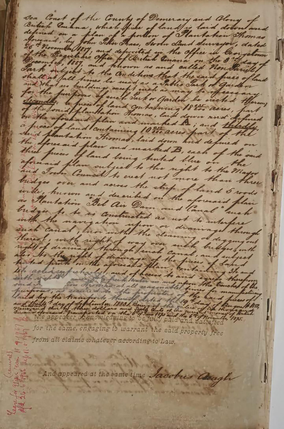
The said Transport it said is referenced as Number 337 of 22nd December, 1887 (Demerara) and describes three portions of land as follows:
Firstly 15 acres, being Part of Pln. Thomas as shown on a Plan by J. P Prass, dated 8th December 1887 SLS. This plan is lodged at the Deeds Registry and is referenced by all subsequent surveys in the area. The area being called “Non Pariel Park” with conditions that the said land can only be used for a public park, gardens and such like.
Secondly 18.035 acres on the same plan, marked “A”
Thirdly 10.235 acres on the same plan marked “B”
The GLSC said that the total area is approximately 43 acres. This is said to be shown on a Plan by J.P. Prass, Crown Surveyor and lodged at the Deeds Registry. The statement said that all references to this plan by a succession of surveyors says it was seen at the Deeds Registry. The GLSC said does not have it on their records.
“It was not compulsory then to lodge it with GLSC although many such records were subsequently obtained. Surveyors are basically trained to conduct research and retrace property with limited information and this is done by examining every piece of available record found”, the statement said.
Prior to the passing of the said Transport, the GLSC said that a survey was initiated on behalf of the Council by Luke Hill, Town Superintendent and Sworn Land Surveyor (acting for the Mayor and Town Council) in 1886 which pre-dates the intended transfer from Hogg, quoted on the plan as the owner. This plan (Number 2253) shows a survey diagram that clearly defines the location of the lands to be transferred, it also offers explanatory notes to that effect. A certified copy of this plan is part of the GLSC records, the statement said.
“That plan shows the area as being from Camp Street to a block of private lands that adjoins Vlissengen Road (lands later owned by Caetano) and from Cummings Canal (inclusive of) going north up to the drain south of Longden Park (now Queen’s college).
“The area was subsequently surveyed back by C. Chalmers, for passing of transport to the Council, a plan that was lodged at the Deeds Registry and not at GLSC.
“Since obtaining the Transport the Council has issued several leases and numerous surveys were done, these surveys refer to Transport 337 of 1887 and gives clear descriptions as to location, all of these surveys were done on the North and South of Woolford Avenue, none on Carifesta Avenue (which was Kelly Dam before). Most of these surveys were actually initiated by the Council for the purpose of issuing leases”, the GLSC said.
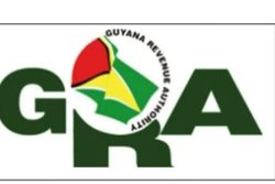
GTI
It said that the first such survey by J.T Seymore covers the entire block of land held under the said Transport 337 of 1887 (the Council’s Transport) whereby they sought to allocate the greater portion of the eastern part into house lots save and except the area to the west where the Government Technical Institute (GTI) now lies and opposite GTI where the Tennis Court lies, this area being called Non-Pariel Park on that plan and in the Transport.
“Even though the total area is not shown, the GLSC has been able to scan and use software to scale back that plan to obtain the approximately 43 acres quoted with the reserve for Cummings Canal which is not clearly defined on that plan. It may have been possible that Woolford Avenue could come out of that exercise since the 1886 plan did not show it but (the) 1919 plan showed it.
“This scheme obviously failed due to the restrictions on the transport preventing house lots and the Council aborted the process. All subsequent surveys were for education or recreational purposes”, the GLSC said.
Plan 11019 by R. Jaggernauth SLS in 1964 created 4 large plots for the Town Council and refers to Seymore’s plan, claims to supersede it and quotes Transport number 337 of 1886 as its basis. The plan claims to have superseded the 1919 version, the GLSC said.
GTI was acquired through the public acquisition process by Government in 1951 and surveyed by R.M Wong and the Council’s Transport 337/1887 was duly annotated.
Other surveys were done for the Council to issue leases for many other organizations such as Indian Education Trust, Central High School, Muslim Youth Council, Gandhi Youth Organization, among others. The annotations are again on their transport, the GLSC said.
In terms of the Carifesta Avenue area, the statement said that the Government of British Guiana and subsequently Guyana surveyed and gave out leases north of Kelly Dam to organizations such as East Indian Cricket Club now Everest (6.17 acres), B.G Boy Scout, next to Everest, Teachers Training Centre, Cable and Wireless (GTT now), Youth Council (later NIS obtained a lease), Saint Stanislaus College and on the southern side to Demerara or Georgetown Golf Club (now the National Park), the Rifle range (now Camp Ayanganna), YMCA, Catholic Youth Club (now Marian Academy) and Queen’s College, Cosmos Sports Club (now GMRC) Malteenoes Sports Club, Transport Sports Club, Post Office Cricket Club (now GPSU).
“This is as far back as 1930’s and 40’s and covers the entire 240.5 acres. Many of these leases expired and were re-issued to the original lessees or new ones where the entities did not exist anymore.
“The GLSC continued to issue leases in the area and is currently processing GMRSC and Malteenoes. These lands along Carifesta Avenue exceed 43 acres and cannot be misinterpreted to (be) that held under Transport 337/1887. In fact, the Northern side has about 45 to 50 acres. Save and except for a lease for a dam (Wireless dam, near GTT) there is absolutely no record of a survey or lease issued to anyone by the City Council for any area along Carifesta Avenue”, the statement said.
In order to account for the Council’s lands, the GLSC provided a list of surveys registered at GLSC by various surveyors who refer to the lands held by the Council, many done at the request of them, all in the Woolford Avenue area, some of these leases are annotated on the Council’s Transport. Most of these also list the Transport number 337 of 1887.
Even though this transport is very old there are noticeable annotations as follows, the GLSC said:
Public Acquisition from M&CC for Government Technical Institute, 2.459 acres on a Plan by R.L Wong, which when checked was acquired by Order 27/1951.
Lease by M&CC to Portuguese Club (Later called Non Pariel Park Tennis Court) in 1931- 3.09 acres.
Lease by M&CC to Indian Education Trust College No 347/1960 for 99 years – 4.479 Acres. Now Richard Ishmael Secondary and North Georgetown Primary.
Lease by M&CC for Central High School, later shared by Critchlow Labour College and Tutorial High. 1.96 acres and 2.088 acres.
M&CC to BG Teachers Association (now GTU) -2.436 acres
BG Boy Scout from M&CC -3.525 acres
Sprostons Sports Club (now GNEC) -3.539 acres
M&CC to Muslim Youth Organisation (May now be CIOG)- 2.582 Acres
M&CC to Labour College- 1.361 acres This seems to be GITC based on the date.
St Joseph High School and Stella Maris- 5.88 acres, surveyed for Mayor and City Council.
GYO 2.2 Acres
An area between GYO and North Georgetown 1.8 acres
The GLSC said that all surveys executed on behalf of the M&CC have been in the same area between Camp Road and Vlissengen Road and from the southern boundaries of Queen’s College to Cummings Canal. The surveys all refer to Transport no 337 of 1887.
The Council only has 43 acres and most of this has been basically accounted for through the above surveys. A very large reserve as much as 70 feet and 44 feet for the Cummings Canal was left in most of the surveys”, the GLSC added.
North Georgetown, it said, seems to be on the Caetano Land and not part of Transport 337 of 1887 and as such it was not included. These lands were acquired by government for the construction of Irving Street, according to the GLSC.
The approximate area obtained for the various properties as well as the Cummings Canal reserve basically covers the entire Council property as described in the Transport number 337 of 1887. Instead of a North Canal mentioned in Luke Hill’s plan the route seems to have been changed to rebuild Cummings Canal and fill the North Canal shown on that plan.
It said that the respective plan numbers have been included for anyone to check at the Guyana Lands and Surveys Commission Head Office.
One of the aged transport documents being circulated by both the Mayor and City Council and the Guyana Lands and Survey Commission.
The Table below, the GLSC said provides some details of these surveys: