Repsol is set to begin oil exploration again with a fresh round of 3D seismic surveys in the offshore basin close to Suriname with a view to determining the hydrocarbon potential that may lead to a US$200 million drilling campaign after 2015.
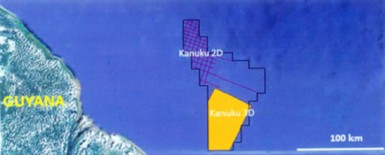
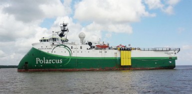
The Spanish oil giant has hired the services of seismic surveying company Polarcus to carry out the surveys in the Kanuku Block offshore Guyana
which will last for about 90 days. The survey will commence tomorrow and is due for completion on December 9, 2013. It will be done at a cost of US$35 million.
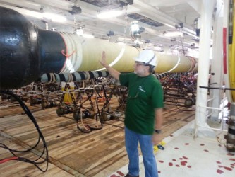
Members of the media, Minister of Natural Re-sources and the Environment Robert Persaud, officials from the Guyana Geology and Mines Commission and officials from Repsol were given a tour of the seismic vessel yesterday.
Leading the tour, Mike Phelps, Polarcus Party Manager spoke of the clean technology of the newly constructed survey vessel, Polarcus Asima, which arrived in Port Georgetown on Thursday.
“We put out a much cleaner sort of footprint, we don’t put out the emissions that older vessels do.
We don’t burn as much fuel and make as much mess of the environment so that is the main difference [with Polarcus],” he said. “Older vessels coming here 10 or 15 years ago would have pulled one or maybe two streamers, we are actually doing these surveys with 12 streamers and some boats are actually going up to 16, 18 streamers,” he said.
Allan Kean, Repsol’s Atlantic Basin Exploration Manager, said the new technology that Polarcus is employing gives continuous seismic data in such a dense fashion that one is able to display it in a cube and look at it in three dimensions. He said the technology is phenomenal compared to the older technology with higher resolution and more definition of the seismic data.
Kean said the more streamlined data could be used to identify hydrocarbon saturation and differences in the rock composition that must be encountered and will help in deciding where exactly to drill for oil.
Because of the high quality of the data there could be a better mapping of all of the near surface events and that will be helpful in avoiding the problem of pressure building up in the pipes which led to an abandonment of the last well sunk by Repsol.
Petroleum Manager at the Guyana Geology and Mines Commission Newell Dennison said since its last attempt Repsol has identified some critical issues and has designed the current survey to try and address those issues. “So to make the distinction, if someone is coming in to do a seismic survey on a first shot, they probably would not design a survey as it is done here,” he said. “But having done what has been done and having refined the areas that you are potentially interested in and observed what the problems are, you design the survey to deal with some of those issues,” Dennison said.
Kean said, “If we can find something that’s got the same size prize as Jaguar but has got less [pressure] and less cost, it’s a no-brainer.” He said the new survey will also incorporate the old 3D seismic done in 2008 for an overall mapping so that there is one “giant 3D data. We are going to take the old 3D seismic shot in 2008…we are going to overlap the new data,” he said, noting that there is about a five-kilometre overlap between the old and new data. “We are going to reprocess it altogether to come up with one giant cube that would allow us to touch Jaguar to the upper Berbice canyon to see what the relationship is with the rock geology and the hydrocarbon,” he said.
On July 16 last year, Repsol and its partners announced the end of the six-month drilling operation at the Jaguar well in the Georgetown Block; there was no discovery of oil in commercial quantities.
They had said that it was not safe to go deeper, because of high pressure which had been built up to dangerous levels.
The Jaguar-1 well was stopped at a depth of 15,998 feet and the decision to plug and abandon was taken unanimously by all partners based on the high pressures encountered.
At the time the partners signalled that the light oil samples recovered held “significant promise” and government said the evidence of petroleum occurrences was encouraging to all parties. The partners to the offshore Georgetown Block were Tullow Oil plc (30%), CGX Resources Inc (25%), YPF Guyana Ltd (30%) and Repsol Exploracion S.A. (15%).